
Whether you have questions about our trail conditions, need assistance planning your visit, or want to share your experience, we’re eager to hear from you!
Elora Cataract Trailway Interactive Map
Trail Parking Areas
Elora
6479 Gerrie Road
Fergus
389 Beatty Line
Belwood
Belwood Lake Conservation Area with paid admission
Sideroad 10 beside South Broadway St
Orton
022037 Erin-East Garafraxa Town Line
Hillsburgh
11 Station Street
Erin
235 Ross Street
Side of Mississauga Rd near Cataract Road intersection
Side of Credit River Road near 5477 10 Line
Trailway Closures
The CVC-owned section of the Elora Cataract Trailway between Trafalgar Road in Hillsburgh and Main Street/ Wellington Road 124 in Erin is closed until early 2027 due to the Erin Wastewater System project. More information and up-dates can be found here or from Credit Valley Conservation.
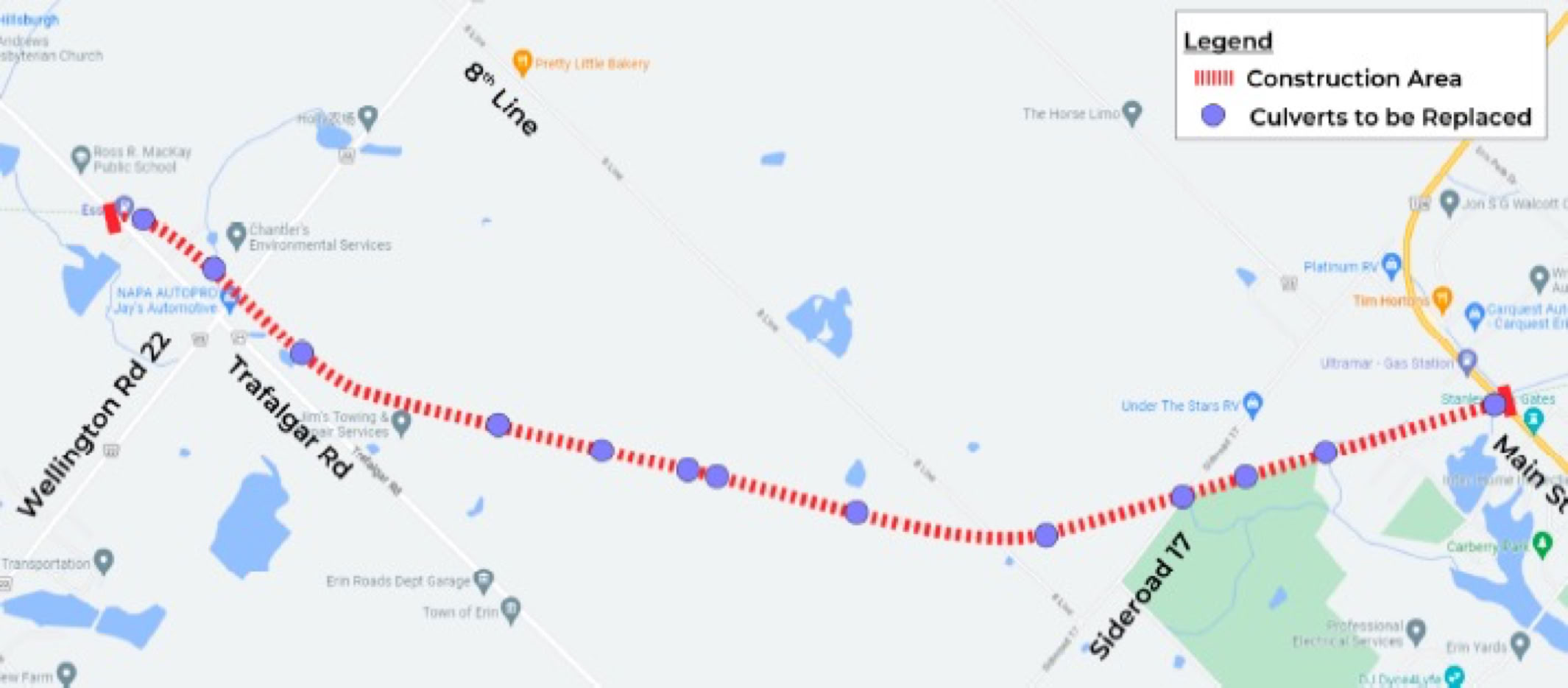
Map from Town of Erin Construction Liaison Meeting (December 9, 2025)
Trail Connection through Fergus

From trailway cross Gartshore Street and continue on trailway descending steep switchback onto Gzowski Street. Turn left onto Gzowski Street and then right onto Forfar Street E, then left onto Victoria Terrace at top of small hill. Cross over Garafraxa Street E (Victoria Street becomes Cameron Street) and then turn right onto Hill Street E and proceed to Gowrie Street N. Turn left onto Gowrie Street N and then right onto St George Street E. Follow St George Street E and W to its end at Beatty Line. Turn right onto Beatty Line and turn left into trailside parking lot opposite Hill Street W. Continue along trailway to Elora.
From trailway, turn right onto Beatty Line and then left onto St George Street W. Follow St George Street West and East across St. David Street N to Gowrie Street N. Turn left onto Gowrie Street N and then right onto Hill Street E and proceed to Cameron Street. Turn left onto Cameron Street that becomes Victoria Terrace and proceed to Forfar Street E, turning right onto Forfar Street E. Proceed to bottom of small hill and turn left onto Gzowski Street and then quick right climbing onto the steep switchback pathway that leads to trailway.
Trail Connections from the Elora Cataract Trailway

Map utilizing Trails & Cycling Routes Caledon Maps created by the Town of Caledon
The red arrow shows the entry location of the Elora Cataract Trailway/Trans Canada Trail into the Town of Caledon (green area) from which you can connect with the following trails: Caledon Trailway, Bruce Trail, Humber Valley Heritage Trail, Oak Ridges Trail, Etobicoke Creek Trail, Greenbelt Cycling Route.
Trail connection to G2G Trailway, Kissing Bridge Trailway via Middlebrook Rd and Cottontail Rd Trail
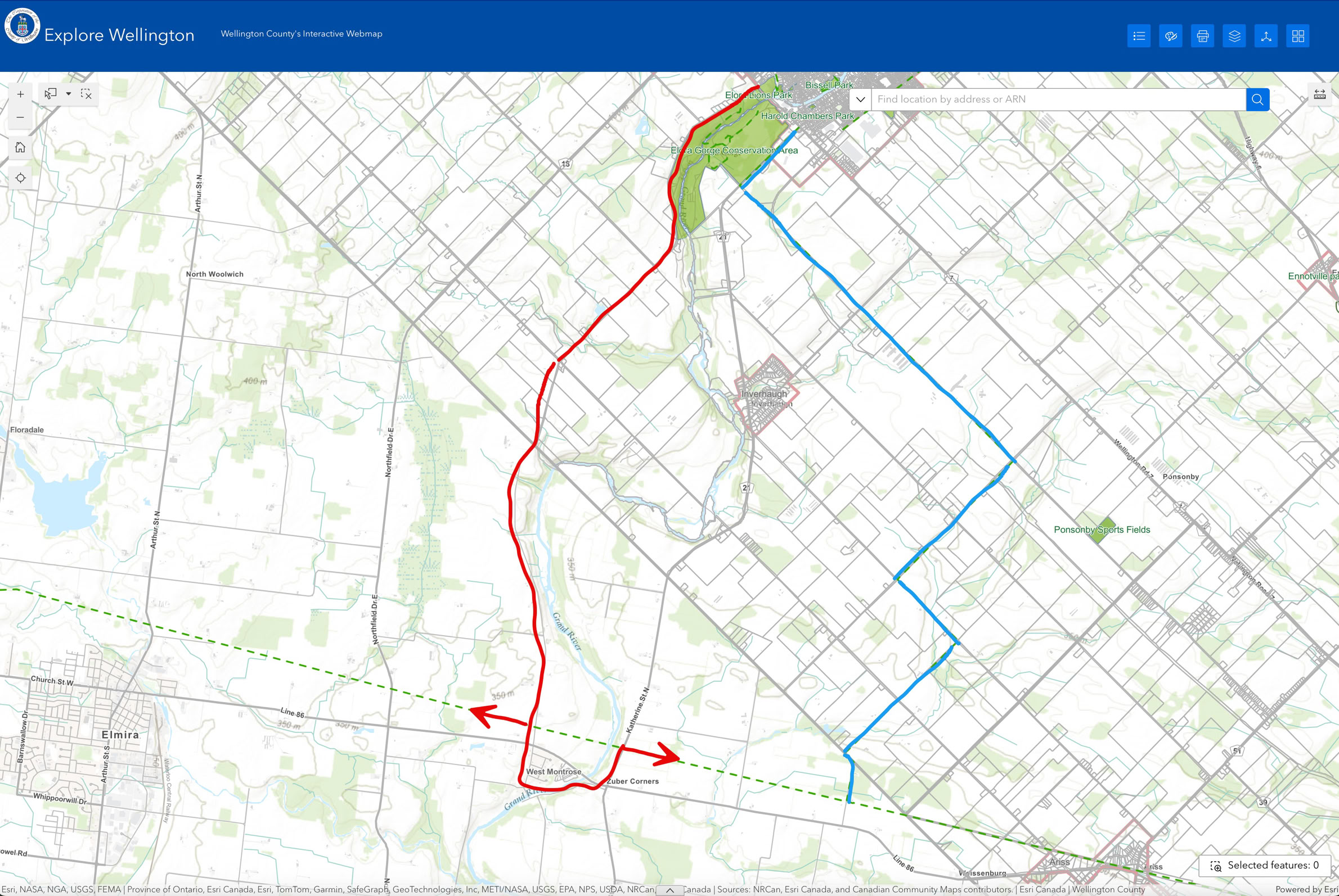
G2G via Middlebrook Road
G2G via Cottontail Road Trail
Follow the blue route, starting at McNab Street in Elora, crossing over Wellington Road 7 onto Wellington Road 21 (WR21). Proceed west along WR21 until you reach the Cottontail Road Trail, opposite the Gorge Park entrance. Head south on Cottontail Road Trail that becomes Second Line E, turning west onto Sideroad 10. Turn south onto Sixth Line East and then west onto Sideroad 12. Turn south onto Weisenberg Road and follow it to the Kissing Bridge Trailway.
Follow the red route passing over the scenic David Street bridge over the Irvine Creek Gorge in Elora, and then cross over Wellington Road 7 onto Middlebrook Road. Proceed west on the Middlebrook Road that intersects the G2G Trailway’s connection from Guelph (green dotted line).
Continue along the Middlebrook Road, crossing over Hwy 86 onto Covered Bridge Dr and follow it into West Montrose and across the covered bridge. Upon exiting the covered bridge follow Rivers Edge Drive to Katherine Street N. Turn left onto Katherine Street N and cross over Hwy 86 proceeding east to the Kissing Bridge Trailway/G2G Trail. The Kissing Bridge Trailway/G2G Trailway trailhead is on you right just before you cross the Katherine Street N bridge. Please see important announcement about West Montrose Covered Bridge below.
West Montrose Covered Bridge
The West Montrose Covered Bridge is closed to all users for rehabilitation until December 2026, as is Letson Park that is being used as a construction staging area. Visit this link for more info.
Reviewing G2G’s map below, take the alternate route shown in yellow to connect with the north and south sections of the G2G trail. Please note Waterloo Regional Road 86 is a busy road.
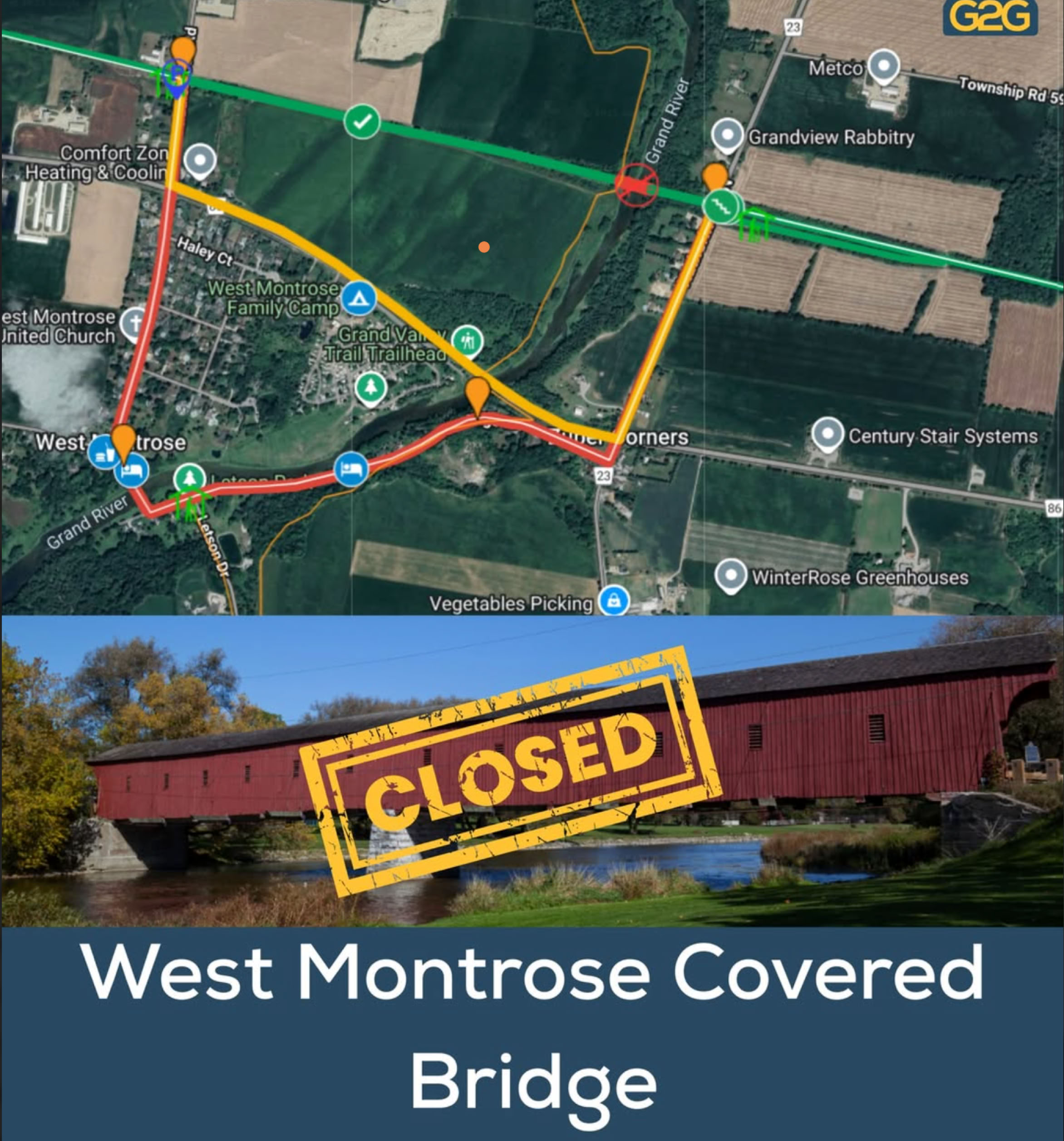
Map and image produced by G2G Rail Trail
Our Kiosks
Our various kiosks orient and educate Trailway users through maps, trailway development, accompanying historical photos and suggested points of interest.


Photo: Courtesy of Sean Carson
Photo: Courtesy of Sean Carson


Photo: Courtesy of Sean Carson


Who We Are
We promote opportunities to connect people with their natural surroundings and an active, healthy lifestyle.
Through collaboration with our conservation partners, public and private sectors of our neighbouring municipalities, and our membership; we protect, restore, and enhance our trailway, greenway corridor, and active transportation connections for the benefit of all.
